El Niño & La Niña
Wet or Dry?
El Niño & La Niña
El Niño and La Niña are the children of the Tropics. El Niño was originally recognized by fisherman off the coast of South America as the appearance of unusually warm water in the Pacific ocean, occurring near the beginning of the year.
El Niño means The Little Boy or Christ child in Spanish. This name was used for the tendency of the phenomenon to arrive around Christmas. La Niña means The Little Girl. La Niña is sometimes called El Viejo, anti-El Niño, or simply "a cold event" or "a cold episode".
Both effects El Niño and La Niña are very important for the climate and the weather in the Philippines. Very simplified one can say:
El Niño brings dry weather and even droughts
La Niña stands for rainy weather and floods
The Niño / Niña Meter aside informs at a glance and is updated automatically by NOAA.
The El Niño Southern Oscillation, or ENSO, is a quasi-periodic climate pattern that occurs across the tropical Pacific Ocean roughly every five years.
It is characterized by variations in the temperature of the surface of the tropical eastern Pacific Ocean warming or cooling known as Niño and Niña respectively and air surface pressure in the tropical western Pacific, the Southern Oscillation.
Current ENSO status

Absolute Water Temperature

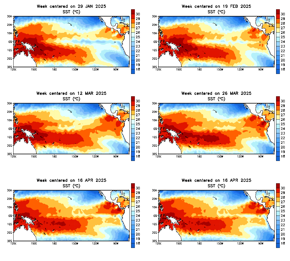
This map shows the development of the Pacific Ocean's surface water temperatures in the last 12 weeks. The Philippines can be found on the extreme left side of the map. In the center are the islands of Hawaii and on the right side are parts of the USA, Mexico, Central America and Peru.
The absolute surface temperatures are in indicator for typhoon/hurricane probability. An ocean temperature of 26.5°C (79.7°F]) spanning through a depth of at least 50 metres (160 ft) is considered the minimum to maintain the special mesocyclone that is the tropical cyclone.
These warm waters are needed to maintain the warm core that fuels tropical systems. A minimum distance of 500 km (300 mi) from the equator is normally needed for tropical cyclogenesis.
Anomalies of Water Temperature

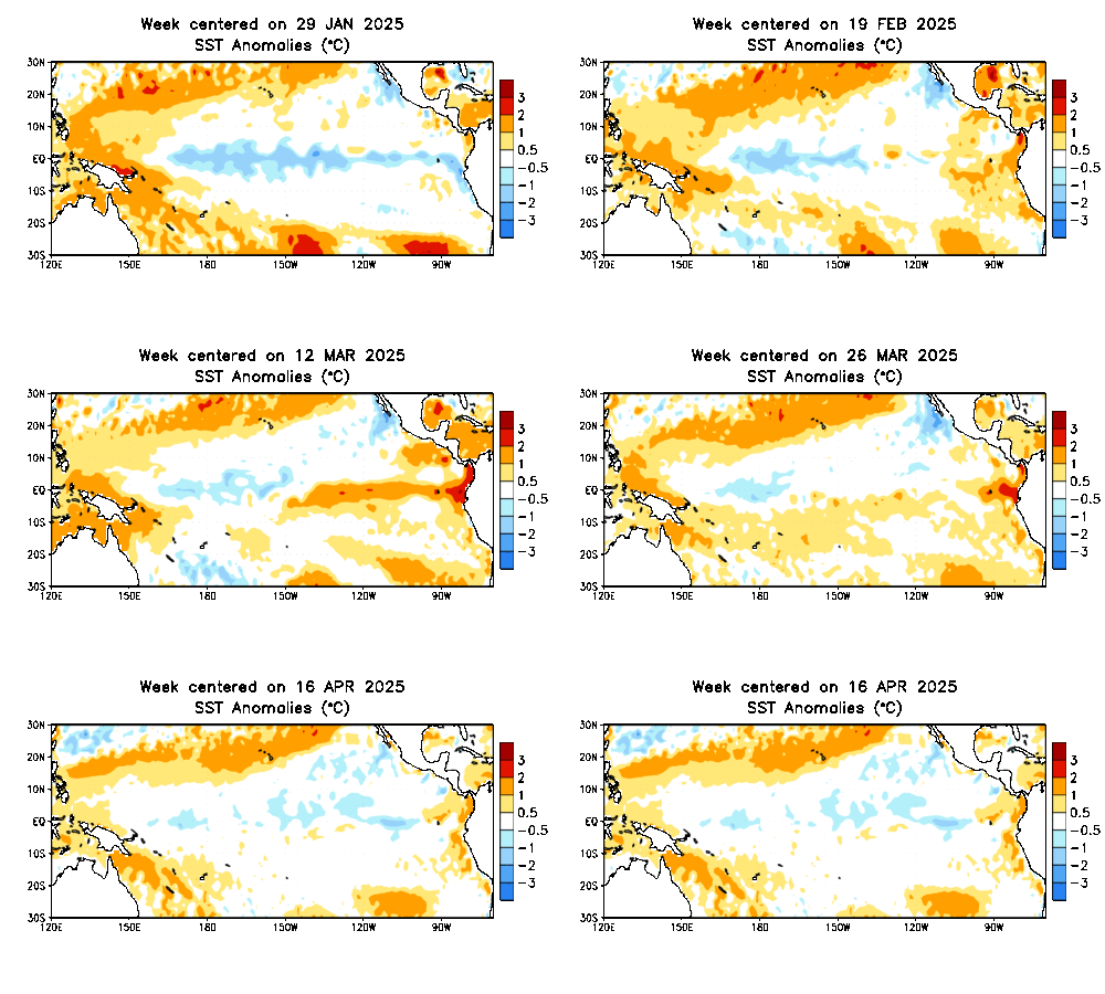
Much more important for the El Niño / La Niña effects are the temperature differences of the surface waters around the equator.
A difference of +/- 0.5°C (white color) is considered to be normal.
A derivation to yellow and red along the equator means warmer equatorial waters = El Niño.
A bluish color along the equator means colder equatorial waters = La Niña
Influence in the Philippines
The most affected people are the farmers. The most touched regions are central and western Mindanao and the Cordilleras.
Mindanao is affected by both, El Niño and La Niña - droughts or floods. The Cordilleras are affected by La Niña - much too much water.
Also other regions can be touched, but then it's rather an exception. Such an exception happened during last El Niño 2015/2016. In many regions there had been no rainfall during 4 months (e.g. Zamboanga and Bohol)
The dam levels as an indicator
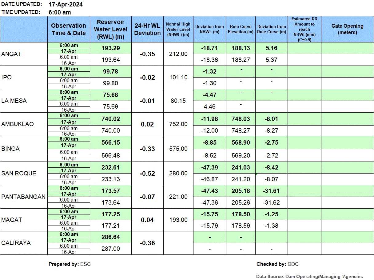
The table shows the daily variation of the water levels in 9 dams in central and northern Luzon.
There are 2 important columns:
- The 24 hours water level deviation
- The Gate Opening
A long during negative water level deviation indicates a strong El Niño effect. It is dry.
When La Niña hits, the water level rises rapidly. The spill gates have to be opened to prevent an overflow of the dams.
The result of such openings are often floods in the lowlands.
CAUTION:
The dam levels change with the seasons. Amihan is usually dry in the north = low levels. Habagat brings rain and fills the dams.

Source: automatically updated by PAGASA (The picture might sometimes be off-line.)